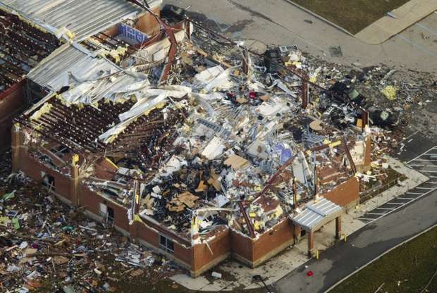
Courtesy: Evan Bentley | photoblog.msnbc.msn.com
Website where photo came from (great to look at): http://rceezwhatnext.blogspot.com/2012_03_01_archive.html
March 2, 2012: Four years ago today
Henryville, Indiana
The March Lion was in full force that Friday afternoon
The small town was put on the map by an EF4 tornado
One of the hardest hit places was the Henryville School district, where there was plenty of carnage.

https://seethinktry.files.wordpress.com/2012/03/henryville-high-school-gym-from-ap-michael-conroy.jpg

http://www.wlky.com/10179518
"Inside Henryville School after tornado damage"

https://seethinktry.files.wordpress.com/2012/03/henryville-high-school-gym-from-ap-michael-conroy.jpg

http://www.wlky.com/10179518
"Inside Henryville School after tornado damage"

Source: http://roundballreview.com/make-a-donation-to-hoosiers-for-henryville-campaign/

chrisbergin.photoshelter.com
Miraculously, everyone in the school building survived.
Along the length of the entire path, eleven people died.
Why does this little town attract me?
In the Weather Channel series "Tornado Alley," (the first few minutes of the documentary) storm chasers are driving along rolling hills as the tornado heads for Henryville. The bridge coming from Louisville, KY into the Indiana state line also draws my attention to the scenery. I went to school in a place with plenty of rolling hills and heavily forested (the piedmont of Virginia).
In the Weather Channel series "Tornado Alley," (the first few minutes of the documentary) storm chasers are driving along rolling hills as the tornado heads for Henryville. The bridge coming from Louisville, KY into the Indiana state line also draws my attention to the scenery. I went to school in a place with plenty of rolling hills and heavily forested (the piedmont of Virginia).

Courtesy of AA Roads http://www.aaroads.com/midwest/indiana065/i-065_nb_exit_000_06.jpg

http://www.aaroads.com/midwest/indiana065/i-065_nb_exit_019_03.jpg
The below video focuses on Henryville, Indiana and the impacts of the March 2012 tornado
No comments:
Post a Comment